When it comes to health care options and outcomes, the country mouse and the city mouse are worlds apart. The space between ‘rural’ and ‘urban’ varies greatly, and the shades of gray matter when assessing populations’ access to resources and exposure to hazards.
That’s an important theme in a new study led by Ozi Iyalomhe, a research fellow at the University of Maryland Institute for Health Computing (UM-IHC) and a Ph.D. student in epidemiology and human genetics at the University of Maryland School of Medicine (UMSOM). His research suggests that using more complete data and finer distinctions of ‘rurality’ can improve understanding of resource access and health impacts, informing place-tailored policies and interventions. The paper was published in JAMA Network Open on April 3, 2026, with co-authors Shuo “Jim” Huang, a UM-IHC postdoctoral fellow, and Rozalina McCoy, director of UM-IHC’s Center for Population Health and an associate professor of medicine in UMSOM.
“Treating ‘rurality’ as a monolith does not adequately capture variation in exposure to social determinants of health in Maryland’s populations,” Iyalomhe said.
Social determinants of health (SDOH) refer to the conditions in which people are born, live, work and age, shaped by an uneven distribution of resources and hazards. For this study, the researchers considered health care access, food access, economic environment, housing environment, educational access, transportation, civic access, community safety, gun violence and environmental hazards.
As differences in health outcomes for people living in rural versus urban areas have widened over time, “we’ve long needed a way to more precisely quantify the drivers of poor outcomes down to the household level,” Iyalomhe said. “In this study, we have it.”
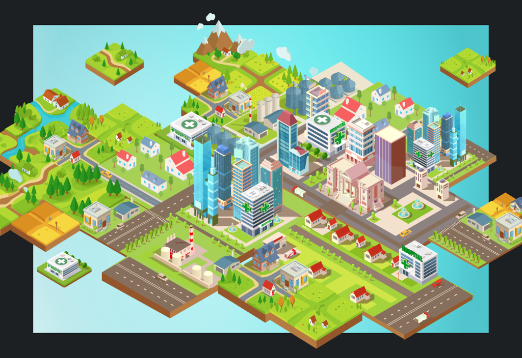
The team used a new tool called GPS-Health, a UM-IHC-developed program that plots the geographic patterns of SDOH at the individual address level. The researchers entered all 2.1 million Maryland addresses, each of which they categorized into one of four categories on a “rurality continuum”—urban, large rural, small rural and isolated rural areas. This approach acknowledged factors like mixed land use, overlapping vulnerabilities and distinct coping strategies when measuring people’s proximity to health services and hazards.
Data in the rough
Most tools that assess SDOH assign a single numeric score across diverse socioeconomic and environmental domains to large, often heterogeneous geographic units, such as counties or census tracts. This “smoothing out” of the data can obscure local variation, reduce accuracy in assessing individual-level risk and offer limited actionable guidance compared with address-level information, Iyalomhe said.
“With our strategy, we’ve taken a more granular look at the state’s SDOH than anyone has done,” he said. “If you’re going to draw a conclusion about Maryland’s drivers of health, using the GPS-Health tool is the way to do it.”
The team’s findings agreed with previous studies showing that rurality on average coincides with longer distances to both health resources and hazards. But the continuum approach provided much finer-grained information than previous reports. For example, it revealed that isolated rural areas—with high proportions of older adults and people with disabilities—were up to 5 miles farther from the nearest hospital, pharmacy and Supplemental Nutrition Assistance Program retailer than urban addresses. Also, federally qualified health centers were closest to large rural addresses.
And unlike previous studies, the GPS-Health tool enabled the UM-IHC researchers to go beyond simply noting the problem of social vulnerability.
“It tells us exactly what and where the problem lies and how it can be solved,” Iyalomhe said.
So, though an urban address may be closer to hospitals, “that household is also closer to sites of gun violence, eviction and so on,” he said. “Any planning about where to add a health care center would need to consider this particular social vulnerability. More broadly, this data can inform policymakers with more precision on how to efficiently allocate resources to do the most good for real populations.”
Sitting in traffic
The researchers’ next steps include enriching the GPS tool with more real-world data, including the time it takes to reach health care facilities from a particular address.
“Our study was based on the crow’s flight, but people in real life are meandering through infrastructure and sitting in traffic,” Iyalomhe noted. “It’s important to account for that, as it could change the assessment significantly.”
For instance, someone who lives in a small rural area may have a longer distance to travel to a hospital, but lighter traffic and less congestion might mean it takes less time than traveling from the suburbs or within a city. Distance alone doesn’t tell the whole story.
The project sets the stage for other states to use GPS-Health and the rural continuum approach to better inform decision-making that improves health outcomes—for the country mice, city mice and all the mice in between.
***
The paper, “Community Resources and Hazards Across the Rural-Urban Continuum,” by Oshozimhede E. Iyalomhe, Shuo Jim Huang, and Rozalina G. McCoy was published in JAMA Network Open on April 3, 2026.